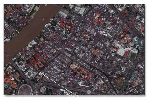
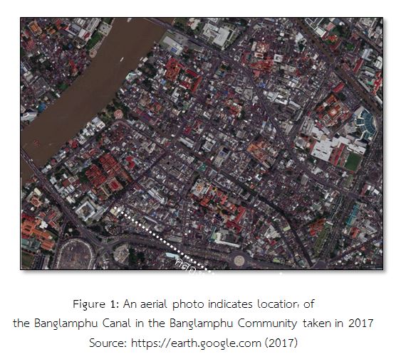
This aerial photo shows the position of places in the Banglamphu community such as royal family members’ royal palaces, noblemen’s former residences, official places, religious places, and stores including roads or alleys. Some were walkways, some were canals which were later filled with soil, some were built as new roads. These were changed and developed over time. The only thing that has not changed since the establishment of Rattanakosin however, is the Khlong Rob Krung or the Rob Krung Canal, also known as the Banglamphu Canal. The Rob Krung Canal is a long canal that flows around the city. This is clearly shown on the map. Local people use these names for the Khlong Rob Krung or Banglamphu Canal, depending on the place it flows through. Although its importance has changed following the urban development, it is still indispensable to the Banglamphu people.
Moats, the concept of structure, of one of the elements of ancient cities.
Since ancient times it has been essential for men to find a reliable source of water. With the rise of permanent settlements, places which were near water resources were chosen, for example: canals or seaboards. This enabled them to create agricultural areas to grow food, which in turn allowed the communities to grow and develop routes for connecting to other communities. Because of this, the administrative center was moved to a higher more accessible area. Water remained a major consideration, so they developed water management systems.
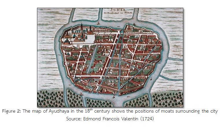
According to evidence of water management, men made long narrow holes around the city called moats, which could be connected to rivers. Piles of earth from digging moats were used as levees which were parallel to the moats and identified the boundary and location of the city. Examples of the a fore mentioned moats and levees in Thailand, are in the ancient cities in the northern region, The Dvaravati Kingdom in the central region and Thung Kula Ronghai in the northeastern region. When the cities were larger, moats were developed parallel to the city walls which were made from bricks, for example: the city walls in Chiang Mai, Sukhothai, Nakorn Sri Thammarat, Adyudhaya and Thonburi. Later, they were the prototype of town planning in Bangkok. The objectives of the moat constructions were:
1. To provide water for everyday use and to prevent water shortages. The moats were also used as a reservoir for irrigation and to mitigate flooding.
2. To be used for water transport and to connect to sea routes.
3. To show the boundary of the city.
4. To form a defensive perimeter around the city.
Khlong Rob Krung (the Canal around the City): the Moat in the Early Rattanakosin Period
King Rama I established the new capital city at the east of the Chao Phraya River in 1782. To expand the city at the east of the Chao Phraya River, he had Khmer laborers to dig a canal from Wat Banglamphu, or Wat Sangveswitsayaram in the present, to the south at Wat Sam Pleum, or Wat Chakkawat Rachawat Woramhawhiharn in the present, connecting to the Chao Phraya River. The canal originally was about 3,426 meters long, 20 meters width and 2.5 meters depth. It was bestowed the name "Khlong Rob Krung” (Khlong means a canal, Rob Krung means around the city, so Khlong Rob Krung means the canal around the city) or the Rob Krung Canal by King Rama I. The city walls, forts and gates were also built by Lao laborers from Vientiane. They were parallel with the canal, and all were built for the city prevention. They were imitated the construction in Ayudhaya where was surrounded by natural moats such as the Pa Sak River, Lop Buri River and Chao Phraya River. In the Ayudhaya period, Khlong Kue Na (Kue Na canal) was dug to connect the rivers making Ayudhaya became an island, and moats and city walls were build as the city prevention.
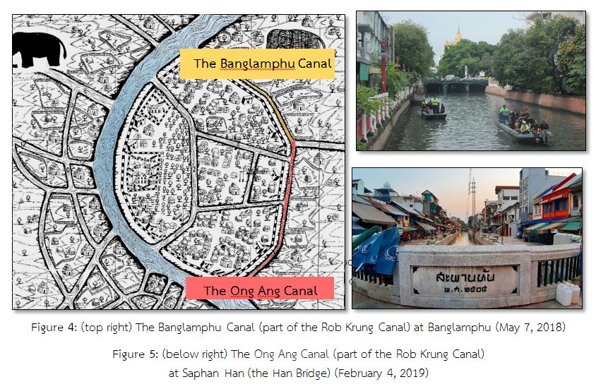
The Rob Krung Canal was made during the establishment of the capital city. Because of its length, people did not call "Khlong Rob Krung” following the given name by the king. They called the different names depending on the place where it flowed through; for example, a water passage from Wat Sangveswitsayaram to the Golden Mountain at Wat Sraket was called "Khlong Banglamphu”(the Banglamphu Canal), a water passage from Wat Sraket to Wat Chakkawat Rachawat Woramhawhiharn was called "Khlong Wat Choeng Len” (the Wat Choeng Len Canal). Wat Choeng Len is the original name of Wat Bopit Pimuk. When Sapan Han (the Han Bridge) was built over the Rob Krung Canal at Sampeng – Pahurat, the canal was called "Khlong Sapan Han” (the Sapan Han Canal). Some called "Khlong Ong Ang” (the Ong Ang Canal). Ong and Ang in Thai means jars and pots respectively because in the past the water passage at Wat Choeng Len was a pier for cargo ships containing pottery from China and Mon. 1982 A.D. was the year of 200th anniversary of the establishment of Rattanakosin, the cabinet approved a proposal of changing the canal’s name offered by the Committee of the Rattanakosin Project. The canal’s name which was called different names was changed to Khlong Rob Krung (the Rob Krung Canal) to conform to historical evidence.
The Banglamphu Canal: From the Canal Surrounding the City to Water Transport Route
The main purposes of making the Rob Krung Canal were to identity the boundary and prevent outside enemies; however, another important purpose was water transport route. The Banglamphu Canal was the main water transport route in Banglamphu, and there were also other branch canals connecting near places. They became the waterway network in Banglamphu.
According to the waterway features, the waterway network in Banglamphu was classified to 3 types which were:
1. The main canals: they were both existing canals before the establishment of Rattanakosin and new canals after the establishment of Rattanakosin.
2. The canal branches: they connected to the main canals and were used for transport. They were both the new canals, connecting to the main canals and rivers, and the canals developing from narrow canals (Lam Pradong) in the gardens.
3. Moats: they are used to be temples’ or important places’ boundaries.
Before creating the Banglamphu Canal, the Banglamphu community during the Ayudhaya period was assumed to be the same physical characteristics as other areas in Bangkok where there was a moderate community surrounding a temple, a center of the community, such as Wat Sangveswitsayaram, Wat Sam Phraya and Wat Chana Songkram. These temples were evidentially built before the establishment of Rattanakosin. The others were agricultural areas. Until the reign of King Chairaja Thiraj during the Ayudhaya period, Khlong Lad Bangkok (the Lad Bangkok Canal) was created at the mouth of Khlong Bangkok Noi (the Bangkok Noi Canal) and Khlong Bangkok Yai (the Bangkok Yai Canal) in order to reduce the distance. These canals became new small branches of the Chao Phraya River flowing through the west of Banglamphu in the present.
When Thonburi was established in 1768 as the new capital city, moats were created. At the east of the Chao Phraya River, a canal were created to connect to the Chao Phraya River beginning from the old wall at the end of Wichai Prasit Fort or Pak Khlong Talat area (a market at the mouth of the canal) to the north at the Teparak Shrine where is under Phra Pinklao Bridge in the present. Before changing the canals’ name offered by the Committee of the Rattanakosin Project on occasion of the 200th anniversary of the Rattanakosin establishment in 1982, the Rob Krung Canal flowing through the south of Banglamphu was called "Khlong Rong Mai” (the Rong Mai Canal; Rong means a factory and Mai means silkworm) following to the name of the royal silkworm factory, an important place erecting near the Rob Krung Canal.
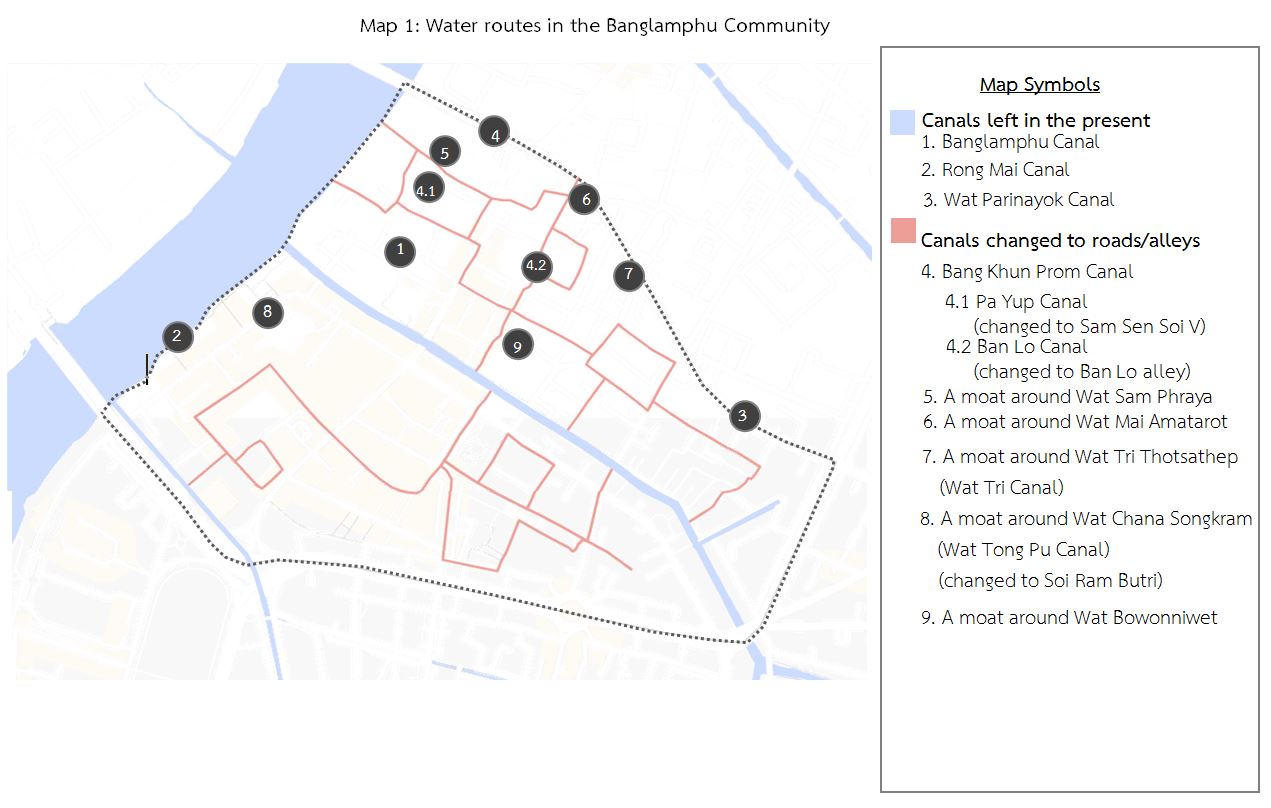
From the Ayudhaya to Thonburi periods, a physical characteristic especially water transport route in Banglamphu and nearby areas was not changed much. In the early Rattanakosin period, Banglamphu was near the Grand Palace where was the administrative center at that time. Its 2 physical characteristics were moats and the Banglamphu – Ong Ang Canal. Moats demarcated the inside and outside city and the Banglamphu - Ong Ang Canal around the city was the main water transport route and later became the Banglamphu Canal network connecting the Ong Ang Canal. The important branch canal was Khlong Maha Nak (the Maha Nak Canal). It was a route connecting to outside communities. Additionally, the Bang Khun Phrom Canal network was parallel with the north of the Banglamphu Canal. Its mouth of the canal started from the Chao Phraya River. When it flowed through Wat Sam Phraya, it was called Khlong Pa Yap (the Pa Yap Canal), and when it flowed through Wat Tri Thotsathep at Ban Phan Thom community, it was called Khlong Ban Lo (the Ban Lo Canal). Along the Banglamphu Canal, there were canal branches developing from narrow canals (Lam Pradong) and moats around important places such as moats around Wat Chana Songkhram (Khlong Wat Tong Pu or the Wat Tong Pu Canal), Wat Bowonniwet, Wat Sam Phraya, Wat Mai Amatarot and Wat Tri Thotsathep (Khlong Wat Tri or the Wat Tri Canal). These branches and moats were like a link between the Banglamphu Canal and other main canals which were Khlong Rong Mai (the Rong Mai Canal) and Khlong Bang Khun Phrom (the Bang Khum Phrom Canal), and later became the complicated waterway network in Banglamphu and other communities.
The Change of the Banglamphu Canal
After the establishment of Rattanakosin, people living in Banglamphu and nearby communities used the Banglamphu Canal network as the main water transport route. When western culture and new technology spread to Thailand, infrastructure in Bangkok was improved. Building roads changed ways of life. People used roads instead of water transport. Physical characteristics in Banglamphu and other areas in Bangkok were also changed. Some canals and branch canals became narrow and shallow, some were filled with soil to build roads, alleys or grounds to suit for new transport and different ways of life. For example, Khlong Wat Tong Pu (the Wat Tong Pu Canal) was changed to Soi Ram Butri (Ram Butri Alley) and Ram Butri Road, Khlong Pa Yap (the Pa Yap Canal) which was one of Khlong Bang Khun Prom (the Bang Khun Prom Canal) was changed to Sam Sen Soi 5 (Sam Sen 5 Alley).
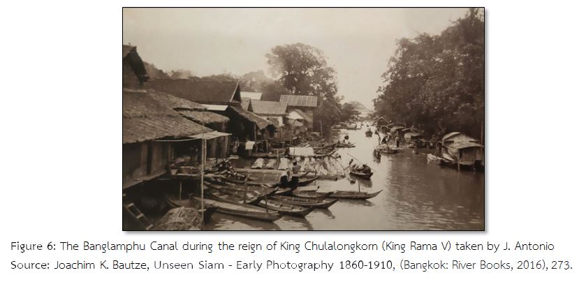
The water routes of the Banglamphu and Rong Mai Canals in the past and the present are still the same. However, there are some changes; for examples, they are more narrow and shallow, their branches where were the former complicated waterway network become roads and alleys. In addition, the mouth of the Banglamphu Canal where connected to the Chao Phraya River was blocked by the floodgate; therefore, there is no waterway network anymore. The Banglamphu Canal as the transport route becomes important less and cannot imagine how many cargo ships and row boats gathering in the past. Nowadays, it is just only one small canal left and houses and private buildings are erected along the bank. However, its importance and value in the present is introduced to be cultural resource of Banglamphu instead of the former moat and complicated waterway network. The 4 cultural values are as follows:
1. Symbolic Value
It is the main value as cultural resource. The Banglamphu Canal is the link between people in the past and the present, the unification of local people and part of Rattanakosin history and the epitome of physical environment and cultural resource.
2. Informative Value
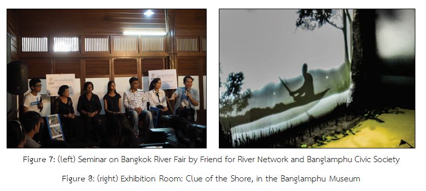
The Banglamphu Canal is the primary source for the historical, social, cultural and environmental studies or research. Additionally, it is the informative source about history, society, culture of Banglamphu and Rattanakosin history for Thais and foreigners. They are able to learn from exhibitions in the Banglamphu Museum, cultural tourism activities managed by private organizations including seminar attention; therefore, knowledge of the Banglamphu Canal is continuously disseminated and mentioned.
3. Environmental Value
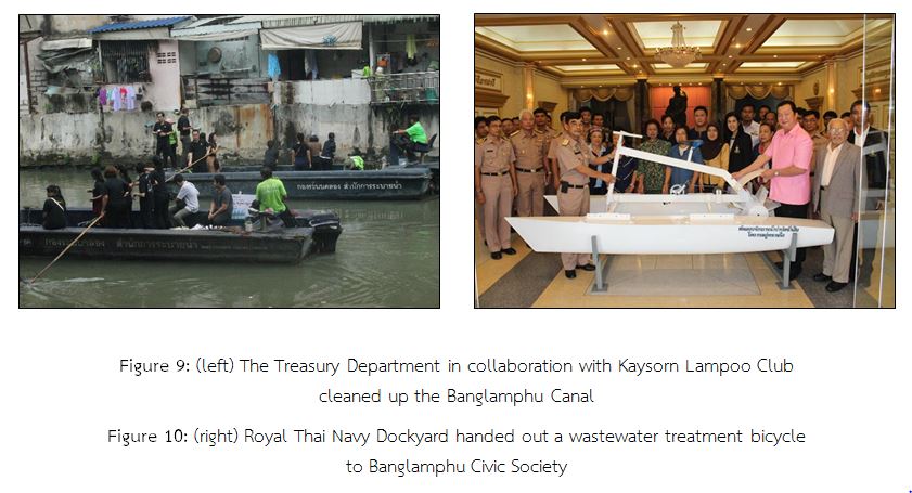
Despite the Banglamphu Canal is a man-made canal, it is accepted to be part of Banglamphu’s ecology and is given precedence as natural environment by the Banglamphu community and many organizations. There are projects of canal improvements such as the landscape revival, cleaning the canal and water treatment.
4. Economic Value
Environmental value and informative value create income from cultural tourism. Local people receive income from cultural tourism in Banglamphu. Additionally, the indirect result of economic value is other places in Banglamphu are well known.
History of Banglamphu community happens and changes along overall history of Rattanakosin. At first, it is a community in the inner Rattanakosin during the establishment of Bangkok as the capital city and a business square later. Nowadays, Banglamphu is developed to be a learning center and a cultural tourist attraction in the Rattanakosin Island. The obvious example of changing uses and part of history in Banglamphu is the Banglamphu Canal. It was used as moat first and water transport later, and it becomes the cultural symbol of Banglamphu. This is the change of a physical area in Banglamphu. All mentions are the basic understanding of ways of life and cultural history of other dimensions in Banglamphu from the past until the present.
-------------------------------------